
Description
Attention! The card only costs folded 19,80 €, rolled 29,80 €.
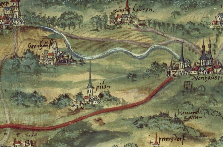
View of the Goldene Aue from north to south anno 1578. In particular, the map shows the course of the country road from Sangerhausen through the Goldene Aue, how it sweeps the Sachsenwarthe and moves through the Stolberg county of Hohnstein to Ellrich.
Places listed are among others: Ellrich, Tettenborn, Carefully, Branderode, Mackenrode, Klettenberg, Bad Sachsa, Steina, Bleicherode, Harburg, Nordhausen Salza, Stockey, divorces, Carefully, Walkenried, Ilfeld, Sülzhayn, Werna, Appenrode, Königerode, Wiegersdorf, Woffleben, Bischofferode, Rüdigsdorf, Crimderode, (Krimderode), Petersdorf, sky garden, Werther, Salza, Sundhausen, Kelbra, Auleben, Herring,Rothenburg, Kyffhaeuser, Görsbach, Urbach, Stempeda, vents, Rottleberode, Breitenstein, Stolberg, Neudorf, Straßberg, Harzgerode, Königerode, Braunschwende, Wippra,en, Sachsenburg, bridges, Holstedt, Berga, Roßla, Burg Honstein, Ebersburg, Buchholz, Herrmannsacker, Neustadt, Rodishain.
Those: template and repro: Saxon State Archive, Main State Archive Dresden, 12884 maps and cracks, cabinet 1 academic subject 24 No.. 5 (Macro sheet no. 11087)


Reviews
There are no reviews yet.